
QGIS For Beginners Exercise – 5 / How to Create Shapefile's from Excel తెలుగులో in QGIS

Exercise – 5 / How to Create Shapefile's from Excel in QGIS


Create centroids from Excel / CSV data.

Many times, the GIS data comes in a table or an Excel spreadsheet. Also, if you have a list lat/long or X & Y coordinates, you can easily import this data in your GIS project.


  • Open the excel data for lat/long or X & Y coordinates.

Figure 144 - Excel Data with X & Y coordinates

  • Convert Excel data into CSV format.

Figure 145 - Saving Excel data from xlsx format to csv format


  • Choose Layer → Add Layer → Add Delimited Text Layer

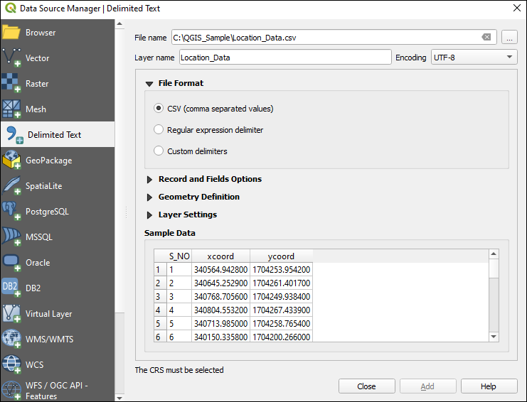
Figure 146 Add Delimited Text Layer Window

  • Click on to browse the csv file
  • Under Record and Fields Option, follow as per the figure 141

Figure 147– Record and Fields Options

  • Check Geometry Definition and follow as per the figure 142

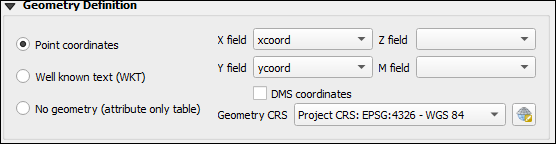
Figure 148 – Geometry Definitions


  • Check for X field and Y fields, if it is lat/long mention X field as Longitude and Y fields as Latitude
  • Select Geometry CRS and provide the CRS information.
  • Click on Add button and Close the Delimited Textwindow
  • Temporary layer will be created and added to Layer panel with <CSV file name> layer. Right click on the layer and save to destination folder.
  • Click on from toolbars section and click on the point layer to view the information of the data.

Figure 149 QGIS with created point layer with csv


Comments

Popular posts from this blog

How to Rename attribute fields in QGIS & How to Rearrange attribute fields in QGIS | తెలుగులో నేర్చుకుందాం

How to Rename attribute fields &  Rearrange attribute fields in QGIS Refactor fields Refactor fields, allows editing the structure of the attribute table of a vector layer. Fields can be modified in their type and name, using a field’s mapping. The original layer is not modified. A new layer is generated, which contains a modified attribute table, according to the provided fields mapping. Refactor layer fields allows to: Change field names and types Add and remove fields Reorder fields Calculate new fields based on expressions Load field list from another layer Add Vector Layer to Layers panel to Drop field(s) Choose Processing → Toolbox → Vector table → Refactor fields Figure 178 - Vector layer with attribute table before Refactor fields Select Input Layer (Ex: Ind_adm1) Select fields to be renamed and reorder (Ex: in the below given example Name_0 has to rename as Name with Length from 75 as 100 and change order of Name_1 under Name_0 [Name after rename] ) Figure 179 - Fi...

Exercise – 15 / How to Create Topology in QGIS తెలుగులో నేర్చుకుందాం

Exercise – 15 /   How to Create Topology in QGIS Topology Creation Topology describes the relationships between points, lines and polygons that represent the features of a geographic region. With the Topology Checker plugin, you can look over your vector files and check the topology with several topology rules. These rules check with spatial relations whether your features ‘Equal’, ‘Contain’, ‘Cover’, are ‘CoveredBy’, ‘Cross’, are ‘Disjoint’, ‘Intersect’, ‘Overlap’, ‘Touch’ or are ‘Within’ each other. It depends on your individual questions which topology rules you apply to your vector data (e.g., normally you won’t accept overshoots in line layers, but if they depict dead-end streets you won’t remove them from your vector layer). QGIS has a built-in topological editing feature, which is great for creating new features without errors. But existing data errors and user-induced errors are hard to find. This plugin helps you find such errors through a list of rules. It is ve...

What is Survey Of India (SOI) Framework?

What is Survey Of India (SOI) Framework? The Survey of India (SoI) framework is a geospatial reference system used in India for mapping, surveying, and geodetic purposes. The framework is maintained by the Survey of India, which is the national mapping organization of India and the oldest scientific department of the Government of India. The SoI framework is based on the Indian Terrestrial Reference Frame (ITRF) and the Indian National Spatial Reference System (IN-SRS), and is used to determine the location and height of points on the Earth's surface with high accuracy. The framework is also used to define the horizontal and vertical reference systems for mapping and surveying purposes in India. The SoI framework provides a consistent and accurate basis for various geospatial applications, such as land management, urban planning, navigation, disaster management, and environmental monitoring. The framework is also used for the production of topographic maps, cadastral maps, and othe...